Map Dowsing
Further water dowsing videos...
dowsing in Zambia
Water dowsing
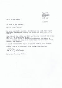
Map dowsing is a very useful skill
to have to enable you to work from home, on a site anywhere in
the world. It helps you to narrow down the target area for
what you are looking for. This saves you time and your clients
money. For example, If you look at the oil and gas section of
this website, you will see a letter written from
the late Michael Poynder PhD, when he was in Australia. He confirms, in this
letter, that his geologist had come up with the same results,
that I had. The difference being, his geologist was on site in
Australia, and I had map dowsed here in the United Kingdom.
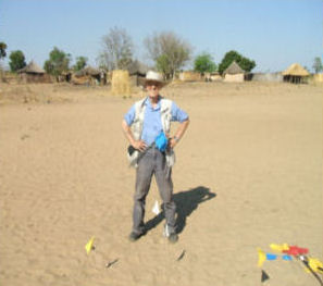
On site at the Orphanage school,
Senanga, Zambia |
Another example is that I was requested to map
dowse for gold
for Clogau Gold in Wales. From home, I successfully map dowsed
three separate areas in the mine which proved to be
successful.
As a professional dowser for the
last 29 years I have used map dowsing for more than fifty
percent of my work. Some of the countries that I have been
asked to map dowse have been Australia, America, Africa,
France, Italy, North Sea, Shetlands etc. |
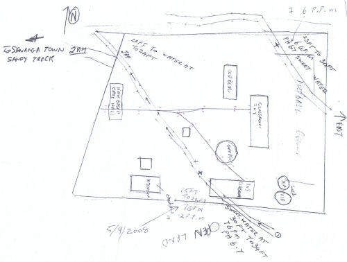
This is the plan of the Orphanage
School that I map dowsed before site dowsing in
Senanga, Zambia. You can see the flow aquifers marked
with lines along a series of small crosses. The flow
aquifer marked in the top right hand corner was the one
eventually chosen to supply the well, as this carried the
cleanest water.
|
I have many references resulting
from this work, see the section on Abenbury Spring Water and
others at the bottom of the home page.
 I use map dowsing for locating
oil, gas, gold, water and geopathic stress.
I use map dowsing for locating
oil, gas, gold, water and geopathic stress.
 I sometimes get asked, how can
this work? No one really knows the answer. My own theory is
that as a professional dowser when I am approached to carry
out a map search I ask the client for a map of the area that
they are interested in. They inform me what they are wanting
to find. The map itself is a connection of a place on our
earth, which then you visualise the location on the map.
Using the pendulum and a marker you slowly move across the
map/plan and suddenly you may get a reaction from the
pendulum, if what you are looking for is there. You then
approach it from a different angle until you get another
reaction. This you continue to do across the plan. This will
narrow it down and depending on the size of the plan, if I
have got a reaction I will generally enlarge it several times
to improve the accuracy.
I sometimes get asked, how can
this work? No one really knows the answer. My own theory is
that as a professional dowser when I am approached to carry
out a map search I ask the client for a map of the area that
they are interested in. They inform me what they are wanting
to find. The map itself is a connection of a place on our
earth, which then you visualise the location on the map.
Using the pendulum and a marker you slowly move across the
map/plan and suddenly you may get a reaction from the
pendulum, if what you are looking for is there. You then
approach it from a different angle until you get another
reaction. This you continue to do across the plan. This will
narrow it down and depending on the size of the plan, if I
have got a reaction I will generally enlarge it several times
to improve the accuracy.
Be aware when checking for underground
sources of water by map dowsing it is important to ensure that
it is not a seasonal flow, or what is sometimes known as a
ghost flow, flow aquifer. This is because they are not
continuous flows, but they leave a reaction of water even when
the water is no longer there. For instance, in the Summer the
flow may no longer be there, but in the Winter the flow will
be there.
When map
dowsing please make sure that there are no other maps beneath the map you are
working from as it can conflict with the map you are working with and give you
false readings. Please ensure that you check to make sure that you are
‘positive’ and not ‘negative’ before you start.
When map
dowsing you will need a water sample in a bottle as a pendulum and you will need
a marker. A marker is the connection to the site. You put the marker on the
plan/map which then gives you the connection to dowse. A marker can be a
pencil, or a pen cap, or a pointed object made out of plastic or wood ( It is
advisable to not use anything metal when dowsing for water as this will cause
interference with your dowsing). Please remember to work as if you were on site.
For example, when you have a map or plan in front of you, you concentrate on
looking for the amount of water beneath the ground that your client needs. You
need to visualise that quantity of water and ask is that amount of water in that
area. If you get the answer ‘YES’ then you ask for the location.
The pendulum
will then swing towards the location. You then move your marker slowly, in the
same direction, and at the same time, that the pendulum is swinging. Eventually
the pendulum will change its course. That is the indication that this is
approximately where the underground source should be. You then mark that point
and then go from the opposite side, as you would do as if you were out on site.
You will then get a reaction again, at some point, near the previous mark that
you have put on. You continue this process on the map until you have completed
both sides of the source of water. You then should have two lines creating a
channel across the plan or map. You can then go to the centre of the channel and
ask for the flow direction. You can roughly work out the quantity of water and
estimate the depth of the water from the centre of the source. If you want to
learn more about map dowsing please look at my courses on this website.
Map dowsing is only ever a guide,
and a site visit is always recommended.
I also teach
map dowsing courses.
Please see teaching section on this website.
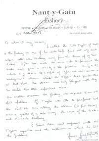
Both of the testimonials on this
page relate to jobs where map dowsing played an important
part.